Arrowhead Trails Portfolio - Municipalities
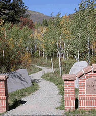
Town of Ulysses, Kansas
Designed and constructed a 0.7 mile, 4' wide, machine built, crusher fine surfaced trail in 2011. Town of Ulysses trail details
Town of Highlands Ranch, Colorado
Designed and constructed 5.1 miles of natural surface machine built trail in 2009 that links into the Douglas County East-West Trail system. Highlands Ranch Community Association details
Town of Buffalo, Wyoming
Designed and plan to construct 4.5 miles of natural surface hiking and biking trail up Mosier Gulch. Buffalo, Wyoming is adding to their extensive trail system that begins in town along Clear Creek with a trail extension that accesses BLM and national forest lands west of town. Buffalo, Wyoming details.
Town of Buena Vista, Colorado
Assisted Town in creating a working, up to date, Town Zoning Map via ArcGIS.
Town of Telluride, Colorado
Arrowhead Trails, Inc. consulted with ERO and ERC to develop the Telluride Valley Floor Plan in February of 2011.
Town of Morrison, Colorado
Construction of 500 LF of crusher fines trail along Bear Creek, part of Morrison's plan to connect with regional parks. Construction of approximately 2,600 linear feet of crusher fine trail for the Morrison Natural History Museum.
 City of Aspen Parks, Colorado
Projects totaling over 5 miles include: Ajax Trail, Ute Cemetery Trail, North Star Trail, Barbee Trail, Benedict Trail, Three Trees, Moore Open Space Trail. Rebuilt two bridges (150’ & 130’ spans) on the Rio Grande Trail. See the Aspen Bridge Construction Slideshow.
City of Boulder Open Space and Mountain Parks, Colorado
Projects totaling over 5 miles of new trail include: Sensory Trail (ADA), Left Hand Trail, Marshall Mesa Trail connector, and the Royal Arch Trail (Step and Trail Reconstruction). Routine maintenance projects include: Mt. Sanitas access, Big Blue Stem Trail, Doudy Draw Trail, and the Foothills Trail. Also developed the Elephant Buttresses and Dome Rock Climbing Trail Access Plan. Consulting on numerous Trail Study Areas: Doudy Draw, Eldorado Mountain, Southern Grasslands, and Boulder Valley Ranch. City of Boulder Open Space and Mountain Parks details.
Town of Buena Vista, Colorado
Barbara Whipple Trail Plan and the Arkansas River Park Trail (1700ft) accessible trail.
 Breckenridge Open Space and Trails, Colorado
Projects totaling over 5 miles of new trail include: Whitewater Park Trails, West Moonstone, Iowa Hill, Warrior’s Mark, Breckenridge Mountain Village, Pence Miller Ditch Trail, and Carter Park Trail.
Castle Rock Parks and Recreation, Castle Rock, Colorado
Design and construct over 10 miles of trail including: Mitchell Gulch Trail, Red Hawk Open Space Trail, South Meadows, Pikes Peak Overlook, Longs Peak View, and Quarry Mesa Trail System.
CRgov.com, City of Castle Rock Parks & Recreation details
Colorado Springs Trails and Open Space, Colorado
Construction of 2+ miles of the Chamberlain Trail and stone retaining walls.
City of Fort Collins Natural Areas, Colorado
Designed and constructed 54 miles of natural surface trails, a 0.5 mile surfaced accessible trail, three natural bridges, and three shared-use trails: Bobcat Ridge Natural Area (Ginny Trail, DR Trail, Valley Loop, and Eden Valley Spur) and the Soapstone Prairie Trail System.
Fort Collins Trails
 City of Louisville Parks and Open Space, Colorado
Provide consulting and volunteer management services for the construction of the Davidson Mesa Trail.
City of Paris, Texas
Trail design and construction workshop for the Public Works to assist in the trail development at Lake Crook Recreation Area.
Town Of Snowmass Village, Colorado
Constructed the 3.5 mile Tom Blake Trail, a portion of the Loop trail around Snowmass. The Ditch Trail was constructed to keep people off road.
 Steamboat Springs Parks and Recreation
The Blue Sage Trail, Mountain View Estates Trail, Howelson Hill Trail and the Spring Creek rerouted around private property to preserve public access.
Town Of Vail, Colorado and USFS
One mile of dozer cut trail the Forest Service crew finished. The North Trail (3200ft) was reconstructed and re-graded because of the erosion caused from high motorcycle traffic.